Nepal, Bhutan and India May 2025

We are about to embark on an expedition to Nepal, Bhutan and India, travelling with friends whom we originally met on the Trans Siberian railway trip in 2007.

We are travelling by private vehicle with local English speaking tour guides. Our itinerary has been customised to suit our group and is quite varied including scenic views of mountains (hopefully including panoramic views of the Himalayas), cultural heritage sites, national parks, local craft bazaars, local markets, temples, museums, ancient cities, monuments including the Taj Mahal, a few hikes (not too demanding), a rafting experience, a boat ride, a jeep safari, a rickshaw ride…. Our tour includes some time to relax - all with camera(s) in hand.

Watch this space to follow our adventures although updates may be spasmodic depending on access to the internet.

Thimphu, Bhutan

DAY 0: Tuesday 29th April - Wednesday 30th April 2025 HOBART - SYDNEY - SINGAPORE - KATHMANDU

Our travel plan was to fly to Sydney on Tuesday evening to be assured of sufficient time to catch our international flight on Wednesday at 11:00. 

Having now met up with Frances, one of our travelling partners, at around 18:00 we boarded the Qantaslink plane and were about to commence our journey to Sydney when the captain announced that the flight was being cancelled due, we heard later to the curfew limitations for this plane to return from Sydney in time for the next morning’s flight.

Somewhat distressed we disembarked and contacted our travel agent Jean and then spent a gruelling two hours in a queue to eventually be told that we could not be accommodated on the Wednesday morning 06:05 Sydney flight.

At this point of anxiety we heard back from Jean that she had managed to get us onto the 06:05 flight and so the three of us headed home; thanks to our neighbour Tim’s generosity in providing transport.

We had a quick meal supplemented by some nerve quelling wine and set our alarms for a 04:00 trip back to Hobart airport, once again thanks to Tim’s “Uber” service!

Frances, Corinne & Jak back home after flight was cancelled

The Qantas desk assistant duly checked us in but only for a later flight to Sydney via Melbourne arriving at mid-day!

After much protesting and derision we were placed in hands of a highly competent Qantas person who found Jean’s booking reference and our blood pressures gradually returned to a degree of normality. A positive aspect of this issue was that now our luggage could be checked right through to Kathmandu which would not have been possible the previous evening. We are deeply indebted to Jean for the amazing assistance she provided us under what can best be described as very troublesome circumstances.

On arrival in a very wet Sydney we transferred from the domestic to the international terminal and subsequently passed through customs and security with minimal delay. At this point we met up with Diana, Chris and Sue who will be our fellow travellers for the next four weeks.

Corinne, Frances, Diana, Chris, Sue & Jak, Sydney International Terminal

Our flight path, SIngapore AIrlines, Melbourne to Singapore

The Singapore Airlines flight from Sydney to Singapore was in a A380 800 plane travelling a distance of 6476 km in just under eight hours. The comfort, hospitality and meal service for the Singapore flight were excellent.

A further travel concern we faced was the limited time we had in Singapore before our flight to Kathmandu with under one hour to transfer by train from terminal three to terminal two. However, despite the large distances we had to walk to get to gate E24 it all worked our miraculously well and we headed off to Nepal in a fairly old Singapore Airline’s 737 800.

We tried to get a modicum of sleep during the five hour flight to Kathmandu as it was approaching 24 hours since we’d left Hobart. Timewise, Nepal is four and a quarter hours behind Eastern Australia.

We landed at Kathmandu’s  Tibhuvan International Airport at 22.20 local time and having acquired our US $30 visas, headed expectantly to the baggage collection area to have the joy of being re-united with our luggage after an eventful day!

We were then met by our very friendly Nepalese guide Gaurab who transferred us by mini-bus to the Kathmandu Airport Hotel where a good night’s sleep was the order of the long day. It was now after midnight and the 1st of May and we headed for bed with a sense of relief and anticipation for the new adventure ahead that will commence tomorrow.

DAY 1: Thursday 1st May 2025 KATHMANDU – NAGARKOT; NEPAL

After a leisurely breakfast we packed our bags and prepared to leave Kathmandu for the time being as we are due to return in a week or so.

Kathmandu has an estimated population of 1.7 million and has a sprawling array of suburban locations resulting in approximately 4 million people in its surrounding agglomeration.

We were met by our bus driver, Om at 11:00 and after loading our bags we then proceeded eastwards through the high density traffic of the airport and surrounds. For at least and hour we drove through suburbs with typically two to three storey buildings most of which looked to lack much in the way of maintenance. Often the ground floor areas were small shops trading in every imaginable wares. The traffic was incredibly chaotic, typical of many Asian cities we’d experienced in past travels.

Eventually the scene changed and the traffic density decreased although the road surface deteriorated as we began a one hour climb leaving Bhaktapur and heading towards the settlement of Nagarkot where we’ll stay this evening.

Nagarkot clings to a 1,985 m hilltop far removed from noise, pollution and the urban sprawl.

View across the valley from near our hotel, Nagarkot

We checked into the Club Himalaya hotel which can be best described as exclusive and exceptionally well appointed providing facilities for even the most discriminating traveller.

After lunch we went for a one hour walk to a westward lookout point and then climbed a nearby hill through a pine forest hoping to find an easterly viewpoint. Unfortunately the hilltop offered a meagre panoramic view and was little more than a helipad. However, to our great joy we found two epiphytic orchids growing on the pine-tree trunks nearby. One of the orchids was in flower and a quick survey revealed that it was plentiful. We managed to get some photos including the second species that had now gone over and all that was visible were seed pods.

Orchid on pine tree, Nagarkot

From our hotel room balcony we have extraordinary northward views of the Himalayas that are so visually dominating that they give the impression of being only a short distance away. The jagged snow covered peaks look amazing in the late afternoon sunshine. Undoubtedly, as the guidebooks suggest, Nagarkot provides one of the best close-range vantage points from anywhere on the Kathmandu Valley rim. From the Annapurnas to Everest, the peaks provide a stunning spectacle that will be etched in our memories forever!

View from our room at Club Himalaya Hotel

View from our room at Club Himalaya Hotel

View from our room at Club Himalaya Hotel

In the late afternoon we had sundowners at an outside bar offering a spectacular Himalayan backdrop. After relaxing with a few cold drinks in the cool evening air we ventured inside to enjoy our evening meal.

Sundownera at Club Himalaya Hotel

Tomorrow we travel southwards towards Dhulikhel where its hillside location offers further stunning views of the Himalayas. We have our fingers crossed hoping we’ll get cloud free conditions.

DAY 2: Friday 2nd May 2025: NAGARKOT – DHULIKHEL; NEPAL

We had free time until 10:30 so after breakfast we spent and hour or more wandering around the Club Himalaya hotel gardens. The gardens are both extensive and well cared for with three different species of tall pine trees forming a perimeter forest. Within the main garden section was an intricate network of paths following flower beds and neatly trimmed hedges. We noticed several different species of epiphytic orchids but only one was still in flower.

Gardens at Club Himalaya Hotel

Gardens viewed from rooftop at Club Himalaya Hotel

At around 10:30 we placed our bags in the bus and then commenced a two hour walk leaving directly from Club Himalaya.

Om, our very informative guide led us initially down a road through the village of Nagarkot where the typical street-front shops were busily involved in their mid morning trade and associated activities.

The path we followed descended quite steeply and the surrounding area became more rural with there being occasional roadside cottages and associated buildings. Most of the farms have their plots on the terraced hillsides which extended across a vast area of the valley below us. Wheat, barley and corn appeared to be the main crops and these seemed to be quite close to reaching harvest time.

Village houses

Terraced farm gardens

Village house

Our morning walk

Man threshing wheat on village house roof

Man sawing wood

The pathway we followed was one where frequent encounters were made with local dogs and poultry but somewhat unexpectedly we noticed numerous cannabis plants growing as weeds along the edge of the road.

Chickens

Cannabis on roadside

In amongst the largely rural setting we were surprised to come across a neatly enclosed hillside enclave owned by the Brahma Kumaris World Spiritual University. This Buddhist off-shoot claims to have campuses around the globe and gauging by the facilities they don’t suffer from lack of finances. The gardens were immaculately maintained with an elaborate temple as a central feature but the topiary elephant in the garden was a particular cause for amusement.

Brahma Kumaris World Spiritual University

The two hour walk ended at the Buddha Peace Park where we rested and had some very refreshing drinks including banana “lassis” which were delicious and made from a ‘runny’ yoghurt.

Buddha Peace Park

The area surrounding the park is the Bageshwari Reserved Forest. This vast forest reserve is regulated to be untouched forever and thus is uninhabited apart from the Nepalese Army School which occupies one boundary section of the reserve to ensure conservation of this large forested area.

Our further travels southwards involved passing through townships of Suryabinayak and Sanga where we were subject to a massive monsoonal downpour which caused roads to be flooded and traffic to be brought to a snail pace.

Rain storm passing through townships of Suryabinayak and Sanga

Rain storm passing through townships of Suryabinayak and Sanga

This dramatic storm soon passed and we were then back in afternoon sunshine as we approached our destination of Dhulikhel where our guide Om was to take us on a walk through the old town.

There is thought amongst scholars that Dhulikhel is an ancient town as revealed by the chronicles of the Llchhavian era of the sixth century AD. Even today there are ancient relics and the buildings within the old city show architectural modes of the past centuries.

Different architectural styles of buildings, Dhulikhel

Sadly, a number of the older buildings in old Dhulikhel show the scars of the terrible earthquake of 2015.

Building damaged by 2015 earthquake

Whilst still in the old city precinct of Dhulikhel we visited a hilltop Hindu temple where the Himalayas should have been visible but cloud and smog precluded such opportunities.

Gate to Hindu Temple

View from Hindu temple

We finished the day’s travels at our hotel, namely the Himalaya Dishya Resort where we celebrated a day of travel and activity with very pleasant drinks and a dinner including interesting Nepalese meals.

View from our room, Himalaya Drishya Resort

Tomorrow we head back towards Kathmandu and will visit some historically significant and interesting locations along the way.

DAY 3: Saturday 3rd May 2025 DHULIKHEL - KATHMANDU; NEPAL

We awoke to find our hillside and whole valley below completely enshrouded in thick fog. This started to lift after breakfast and by the time we were back on the road there was a good deal of blue sky although the air was still quite chilly.

Early morning view from our room at Himalaya Drishya Resort

We headed back through the centre of Dhulikhel and were reminded by Om that this city was a significant trading post in the post 17th century as its position provided a convenient cross-road and staging post for Indian traders from the west and Bhutanese from the east with the Himalayan road leading north to the mountain passes into Tibet and China.

From Dhulikhel we drove towards Banepa and then southwards for half an hour to the town of Panauti which is at the confluence of the Pangumati and Rossi rivers.

Panauti

Our first stop was at the 17th century Brahmayani Temple which is adorned with intricate wooden carvings that have retained fine details even after three hundred years or more.

17th century Brahmayani Temple

Brahmayani Temple

Inside Brahmayani Temple

We then crossed over the very muddy and littered river to one of the only two known pre-Malla structures, namely the Indreshwar Mahadev Temple.

Pangumati River

This temple is famous for its 13th century exquisite woodcarvings especially the ornate roof struts. This important temple was severely damaged by the 1988 earthquake and has been recently restored with French assistance.

Indreshwar Mahadev Temple, Panauti

At the end of the temple square is a museum displaying an impressive selection of Hindu artefacts recovered from temples within the local region over the last seven centuries.        

16th Century wooden hand artefact in Panauti Museum

Mask artefact in Panauti Museum

On our walk back to the bus station we passed through back streets where local people were busy and small shops offering goods for sale with garlic and spring onions being prominently displayed. Some men were photographed playing a card game that appeared to be a variation between poker and rummy.

Garlic drying on the street

Men playing cards

Once back on the bus we drove back up to Banepa observing potato harvesting occurring in the adjacent ‘paddy’ fields. At Banepa we took the minor side road via Nala so as to avoid the roadworks occurring on the main ‘highway’. This led us to our principal destination for the day, that being Bhaktapur.

Bhaktapur is referred to as the cultural capital of Nepal with a history extending back to the early 8th century. It was the Nepalese capital until around the 1600s and is now preserved as a UNESCO World Heritage site.

We first visited Durbar Square being the central part of the medieval city.

Durbar Square, Bhaktapur

The square offers a visual feast of pagodas, towers, monuments and elaborate buildings.  

The Bupathindra Malla statue faces the ‘Sun Dhoka’ or Golden Gate appropriately regarded as an artistic masterpiece. This gate leads into the Royal Palace with its famous 55 windows.

Bupathindra Malla statue

Golden Gate

We walked through the Sun Dhoka into the religious and ritual courtyards and eventually came to the Sundari Chowk or ‘Golden Fountain’, the ritual bathing courtyard of the king.

Golden Fountain, Bhaktapur,

After a lunch break we walked around to the Taumadi Tol (square) which contains two great mystical temples both of which have been restored quite recently.

The Nyatapola Mandi is Nepal’s tallest Hindu temple standing 30m with a total of five storeys entailing elaborately carved timbers with the storeys diminishing in size successively upwards.  It is regarded as the best example of engineering and architectural design for multi-roofed temples with it being balanced on five receding rectangular plinths. The steep central stairway is flanked by huge stone guardians each one being ten times stronger than the one on the plinth below!

Temple

Nyatapola Mandi Temple, Bhaktapur,

Our group at Bhaktapur

In the square there were two vast and elegantly decorated wooden wagons that are used in ceremonial processions and we’re told also participate in a ‘tug of war contest.

Wooden wagon, Bhaktapur

We finished our Bhaktapur visit by going to the pottery square where as it was Saturday, the local potters were not at work. We then visited the visual arts training centre and had a most informative talk on the Nepalese fine art work called ‘Thangka’. This skill requires artists to paint intricate circular patterns on woven cotton with the designs usually being incredibly detailed. Some of these Thangkas are ‘painted’ not with oil paints but with coloured sand.

‘Thangka’

We returned to our bus and Om then drove us back to our hotel in Kathmandu.

We are to spend the next three nights staying at the recently opened Hilton.

Tomorrow we’ll spend much of the day exploring more of the wonders of Nepal in and around Kathmandu.


DAY 4: Sunday 4th May 2025 KATHMANDU; NEPAL

We were disappointed to awake to find that it was raining quite heavily. Despite this, the general plan for the day proceeded and we were driven by Om to the Durbar Square area that forms the nucleus of the old town of Kathmandu.

The founding of Kathmandu, the largest city in Nepal is estimated to have taken place during the Licchavi period beginning in about 300AD. It was during the time of the Mallas dynasty in the 14th century that Kathmandu began to develop in earnest.

The centre of Kathmandu’s old city around Durbar Square was built largely from local timbers and derives its name from the giant pagoda of Kasthamandap meaning “House of Wood”.

When we arrived at the bus terminus near Durbar Square we donned raincoats and collected umbrellas and walked through the narrow alleyways and streets avoiding the high speed motorbikes that ducked and weaved amongst the high density traffic. Eventually we arrived at Durbar Square which is listed as a World Heritage Site by UNESCO.

Jak, Diana & Sue under umbrellas, Durbar Square

The square is a cluster of ancient temples, palaces and courtyards that date back to the 12th century although some of the buildings have had modern day refurbishment as a consequence of earthquakes for which this region is prone.

One of the more unusual aspects of our morning visit was to go to the Kumari Bahal known as the ‘House of the Living Goddess’.

She resides in an 18th century stucco temple with intricately carved windows and doorway. We were allowed to enter the inner courtyard which has even more elaborate woodcarving than the exterior. From the courtyard we could look up to three open window areas and as luck would have it the Kumari or Living Goddess appeared for two minutes or so. The Kumari is considered to be the incarnation of ‘virgin goddess’. Stories of her origin vary but this young Buddhist Sakya girl is referred to as the Royal Kumari because she was worshiped by the king.  

Kumari Bahal

Window where the Kumari or Living Goddess appeared

She never leaves her bahal (house) except for religious festivals and even then she is escorted in a flower decked chariot pulled by devotees.

We then visited the Hunuman Dhoka (Royal Palace) complex which consists of a series of fourteen courtyards. The first two courtyards being Moran Chowk and Sundari Chowk were built for King Pratap Malla in the 16th century. The building has impressive timber work some of which involves erotic carvings.

Hunuman Dhoka (Royal Palace)

In one building we viewed pictures and photographs of Nepalese Kings, former members of the now displaced royal family. Nearby was an elegantly dressed guard on duty holding an ancient rifle and wearing patent leather shoes with orange socks.

Hunuman Dhoka (Royal Palace) - nine storeys

Guard on duty, Hunuman Dhoka (Royal Palace)

As the rain had stopped and there were hints of blue sky we moved on to Swayambhunath which is about 4 km west of Kathmandu.

This is a Buddhist temple with the central stupa thought to be 2500 years old. This main stupa is composed of a solid hemisphere of brick with a white concrete coating. This base supports a lofty conical spire capped by a pinnacle of copper gilt. Painted on the four sided base of the spire are the all-seeing eyes of Lord Buddha.

Buddhist Temple, Swayambhunath

This temple hill is also home to many hundreds of macaque monkeys but fortunately we managed to avoid close encounters. Swayambhunath hill provides a mosaic of Chaityas (stupas with Buddhist relics) and Pagodas. It is regarded as one of the holiest Chaityas in Nepal and also the oldest of its kind.

Macaque monkey on Buddhist Temple

View from Buddhist Temple, Swayambhunath

In the early afternoon we drove to Patan also known as Lalitpur the city of fine arts. Before sight seeing we had a light luncheon.

Roof top restaurant where we had lunch, Patan

Patan (also known as Lalitpur), viewed from the restaurant

Patan is enclosed within four stupas said to be built in the 3rd century AD by Emperor Ashoka.

The city exudes old-world charm with its narrow streets, brick houses and multitude of well preserved Hindu temples, Buddhist monasteries and monuments.

Public water fountain, Patan

We visited the Shikahara style Krishna Temple dating from the 12th century and then spent an interesting hour in the Patan Museum.

The Royal Bath, also known as Tusha Hiti, Sundari Chowk, Patan Durbar Square, Patan

The Royal Bath showing the spout

Royal Palace, Patan

Our group inside the Royal Palace, Patan

To finish the day’s activities we went to a small enclosed shopping centre where high quality pashminas were on sale. In an adjacent room we were introduced to the Buddhist practice of striking copper bowls with a felt mallet to provide vibrational energy to induce mental relaxation and meditation.

Jak being introduced to the Buddhist practice of bowl healing

In the late evening air we headed back to our hotel but the traffic density was so horrific the comparatively short distance we had to travel took ages.

Today has been an exhausting day with lots of walking and standing and by the time we were home we were ready for rest and a good nights sleep.

Sunset viewed from our room at the Hilton

Tomorrow we do go on a sightseeing tour of Pashupatinath and Boudhnath.

DAY 5: Monday 5th May 2025 KATHMANDU; NEPAL

Today’s itinerary meant that we would finish activities a little earlier as we have to prepare for transferring to Pokhara tomorrow and this involves a nine hour drive.

After breakfast Om drove us through the chaotic early morning traffic to Pashupatinath situated about 5 km east of Kathmandu city centre. Pashupatinath temple is one of the most sacred Hindu temples dedicated to Lord Shiva who is both the creator and destroyer. Shiva, the “Great God” or “Lord of the Beasts” is usually represented as a light skinned man with a blue throat, five faces, four arms and three eyes. He typically holds a trident and his  vehicle is the bull, the ancient symbol of fecundity.

On arrival at the site, we commenced a slow paced stroll along the banks of the sacred Bagmati River which was lined with little shops selling trinkets and the usual tourist items including lots of brass ‘healing bowls’ we’d learnt about yesterday. Particularly common were women with multi-coloured powder paints wanting to paint ‘bindis’ on tourist foreheads. The term bindi comes from the Sanskrit word ‘bindu’ meaning point or dot.

Stall with powder for bindis

Bagmati River, Pashupatinath

There were a number of bare chested ‘holy men’ sitting squat legged on the concrete path below us and they were offering ritual blessings to families particularly those having their loved ones cremated. Each had several copper bowls containing oils, flower petals (marigolds) and other mysterious objects.

Holy men on banks of Bagmati River, Pashupatinath

We followed along the elevated pathway adjacent to the river as we approached the temple precinct. We as non-Hindus were not permitted to enter the large, gilded triple roofed temple which apparently was built in 1696.

Temple, Pashupatinath

Further along on the other side of the Bagmati River we could numerous dharmsalas or pilgrim resthouses and cremation ghats. These riverside platforms are also used for bathing access and ritual cleansing although the level of pollution in the Bagmati River looked as if this was unlikely to occur physically!

Bathing platforms on banks of Bagmati River

There were several cremations in progress as we strolled along the river bank and the amount of wood smoke in the air was quite stifling. The bodies are burnt which takes three to four hours and then the ashes are scattered in the river which is holy as the Bagmati River eventually flows into the sacred Ganges.

Cremation in progress

Cremation in progress

Cremation in progress

The tradition of ‘sati’ when wives burned themselves alive on their husband’s funeral pyre has not been permitted since the early 20th century.

At the point where we were closest to the temple, we encountered two large bulls which seemed used to tourists although one was unhappy about being photographed and swung his big horned head around to express his displeasure.

We returned to our bus and then drove to the Boudhanath Stupa which is 8 km east of Kathmandu city.

Boudhanath Stupa

Boudhanath is the largest stupa in whole of Nepal and is closely associated with the 16,000 Tibetan community now living in Nepal. Boudhanath is now one of the most flourishing centres of Tibetan Buddhism in the world and this area offers an insight into Tibetan culture.

The stupa has a huge white dome surmounted by the all-seeing eyes of the primordial Buddha. The dome is based on concentric ascending terraces and around the base is a ring of 108 images of Buddhist deities and 147 insets containing prayer wheels.

The area surrounding the stupa is full of activity with pilgrims praying, busy souvenir shops and numerous monks in their maroon garbs accompanied by Tibetan music emanating from the surrounding buildings. As is tradition, walking around the stupa should always be in the clockwise direction.

Boudhanath

We then returned to our hotel and said farewell to our guide Om who has been friendly and knowledgeable ever prepared to answer our many questions over these last three days.

Bus, taxi & motorbike ransport in Kathmandu

Corinne and Sue then went shopping in Thamel hoping to find pashminas, scarves and balls of cashmere wool but were only able to find yak wool and Australian wool.

Tomorrow we leave Kathmandu and head westwards to Pokhara which involves a long nine hour drive and enroute we are to participate in white-water rafting on the Trisuli river.

DAY 6: Tuesday 6th May 2025 KATHMANDU – POKHARA; NEPAL

The day started with an early 06:30 breakfast and after checking out of the Hilton Hotel we were on the road heading for Pokhara by 07:30.

The drive from Kathmandu to Pokhara of about 250 km takes approximately eight hours as the road conditions are subject to major roadworks for much of the way. Even at the comparatively early morning time the traffic in western Kathmandu was very dense and Om, our amazing driver coped remarkably well with numerous trucks, cars, buses and motor bikes moving all around us in seemingly random pathways. The only road rule one suspects is that you give way to the driver who is pushing in front of you!

The Prithvi Highway roadworks seemed to be occurring on at least half the journey and the surface in these areas was often so rough and potholed that a maximum speed of 10 – 15 km/h or less was essential.

Road from Kathmandu to Charaudi

Roadworks on road from Kathmandu to Charaudi

The first 40 km was still semi-suburban with the roadside homes, shops and business places being typically three storey buildings often with drab appearance and minimal architectural character.

The amount of litter along the roadside is seriously distressing and gives evidence that there is no formal garbage collection service operating outside the main Kathmandu city precinct.

After an hour’s travel it started to rain heavily with a sudden monsoonal downpour and the road changed from being incredibly rough to now being rough, muddy and very slippery. Our driver did a remarkable job of negotiating the traffic with extraordinarily difficult driving conditions as sections of the road were so narrow that passing on-coming trucks and buses left no leeway for error.

When we reached Charaudi (Fishling) we stopped and with the rain abating we were introduced to our rafting guide who would take us on our journey down the Trisuli River.

We changed into bathers, shorts and t-shirts and were finally kitted out with waterproof jackets, life jackets and helmets. With paddles in hand we then walked 100 m down a narrow, uneven concrete stepped pathway and then crossed over slippery stones to reach the Trisuli River’s edge.

Diana, Frances, Jak, Corinne & Chris ready for rafting, Charaudi,

Preparing for rafting down the Trisuli River

After a short but adequate briefing we climbed aboard our eight person raft and headed off. Our senior guide and his very capable assistant called paddling instructions whenever required.

Our guides, rafting down the Trisuli River

We travelled 12 km downstream over a period of about two hours in mostly sunshine and balmy conditions. On our journey we encountered rapids every kilometre or so and most were not overly active but we did have three or four highly turbulent descents where waves came right over the bow of the raft and Chris and Jak were totally drenched!

Rafting down the Trisuli River

Along the river path we passed several excavators digging stones and rock from the river bank and loading it into trucks; presumably for the roadworks occurring on the Prithvi Highway.

Excavators on banks of Trisuli River

There were some periods of serenity when we drifted slowly through calm waters with high rock walls forming the river bank with attractive forest foliage forming a backdrop.

We also passed a group of army trainees who were doing a rafting exercise as part of their training. They play a key role during the monsoonal times of July/August when the raging Trisuli River is four metres higher and rescuing stranded people living along the river verges often has to carried out.

Army trainees on bank of Trisuli River

When we reached Manakamana we pulled into the river bank and alighted after two hours of most enjoyable fun plus plenty of paddling exercise.

We changed back into dry clothes and had lunch in a restaurant overlooking the river.

We then had a further two hours of driving to reach our evening’s destination of Pokhara. On the way we had glimpses ahead of the Himalayan peaks including Annapurna which hopefully we may see more clearly tomorrow; fingers crossed!

We arrived at the Temple Tree Resort which will be our accommodation for the next two nights and after drinks we had our evening meals poolside and headed to our rooms to prepare for a 04:45 start tomorrow morning when new commence our exploration of Pokhara.

DAY 7: Wednesday 7th May 2025 POKHARA; NEPAL

We set the alarm for 04:00 and after a quick shower we were on the bus and driving through the dark and empty streets of Pokhara heading towards the hillside township of Sarangkot. Sarangkot is the recommended place to watch the sunrise over the Himalayas.

The bus trip took about thirty minutes and involved a steeply climbing and narrow road involving many tight ‘s’ bends. Near the top we left the bus and walked the last half kilometre to the 1,592 m pinnacle and waited expectantly for the sun to rise and the misty atmosphere to clear.

Rhododendron beside path, Sarangot

The first peak to be cast into sunlight was Dhaulagiri (8,167 m) and next the towering fishtail peak of Machhapuchhre (6,893 m) which is relatively close to Pokhara and this enhances one’s perception of its size.

Sunrise viewed from Sarangot

Machapuchare from Sarangot

Sue, our guide Tenzing, Corinne and Jak at Sarangot

Sunrise viewed from Sarangot

Sun rising over Annapurna

Machapuchare at sunrise

The least misty and hence most impressive section of the Himalayan range viewed this morning was Annapurna I (8,091 m) and its extension towards Annapurna II and Manaslu. Although the visibility was certainly not perfect the visual splendour of this magnificent panorama was captivating. The early morning viewing is recommended as the high peaks tend to become cloud covered later in the day.

Our guide Tenzing had brought hot coffee for us which we enjoyed while chatting with an Australian couple from Bendigo who had driven a VW Amarok over the last year from the UK to Nepal via the ‘Stans’.

On our descent we photographed the giant golden statue of Heramba the five headed elephant god and the associated temple wall with its numerous water taps. The five elephant heads are believed to represent the five elements of nature; earth, water, fire, air and the heavens.

Statue of Heramba, Sarangot

Temple wall with its water taps

Sarangkot  and the surrounding hillside villages are special locations from which many of the Gurkha soldiers originate. These famously brave men who have bolstered the forces of British and Indian armies over the years are revered for their tenacity and loyalty in warfare since the late 18th century. On our way down the hill from Sarangkot we encountered groups of young men training to become Gurkhas by running up the steep incline and then stopping to do ‘press-ups’ and hand stands. The attainment of supreme fitness and strength is the baseline requirement for even consideration of becoming a Gurkha. Reaching Gurkha soldier status is regarded as the pinnacle of physical, mental and personal achievement in Nepalese society.

 A little further down the hillside we stopped and climbed steps up to the Bindyabasina Mandi Temple which is one of the oldest temples in Pokhara and dedicated to the goddess Bhagvati.

Bindyabasina Mandi Temple complex, Pokhara

We observed a group of young teenage Buddhist boys undergoing a ‘coming of age’ ceremony which includes having heads shaved and gaining instructions on how to lead a future married life. Men typically marry at around age twenty three. The temple is also frequented by devotees who bring up male goats and roosters to be sacrificed in the presence of Bhagvati’s spiritual blessing. We saw the gory chopping block and long blade used to perform these sacrificial offerings.

Chopping block & blade

We returned to our hotel in Pokhara city and had a leisurely breakfast.

After breakfast we drove to the city’s lake that was a prominent spectacle seen during the morning’s hillside travels. We were delighted to note the general cleanliness and absence of litter within the city streets; quite different from Kathmandu.

Jacaranda, Lake Phewa Tai, Pokhara

The 2.5 km long lake called Phewa Tal was formed by damming the city’s river about fifty years ago.

On arrival, our group clambered aboard an old fashioned steel hulled paddle catamaran powered by a local who pedalled with apparent ease to take us about 500 m across the placid waters to a tiny island in the middle of the lake. There were many similar vessels to ours and brightly coloured canoes on the water as we followed the shoreline passing under two magnificent jacarandas in full flower. We passed the ‘boat house’ of the winter palace of the murdered King Berenda.

Paddle catamaran, Lake Phewa Tai

Island on Lake Phewa Tal, Pokhara

On the island there was the small Tal Barahi Temple dedicated to the god Varahi. Large carp were being fed pellets by tourists and the action was frenetic.

Tenzing then took us to visit his home ‘suburb’ commonly referred to as the Tibetan Refugee Camp. Following the Chinese invasion of Tibet in March 1959 some 80,000 Tibetans including the Dalai Lama were forced to flee to India, Nepal and Bhutan. Amongst these Tibetans and their families there are now about 500 living in this refugee camp and sadly, they’re denied opportunities of gaining Nepalese nationality or acquiring Nepalese passports.

Tibetan refugee Camp, Pokhara

We spent a good deal of time in the Pashiling Tibetan Photo Gallery where much of this terrible time for Tibetans is recorded in text plus numerous photographs from this time of the genocidal Chinese invasion.

In a more encouraging light we then watched a woman hand weaving a rug depicting a yak. Interestingly, the wool she was using was from New Zealand. The rugs and carpets on sale were of the finest quality and were extraordinarily beautiful and yet comparatively inexpensive.

Woman hand weaving rug, Tibetan refugee Camp, Pokhara

We next visited the Gupteshwor Mahadev Cave which is apparently a world famous tourist destination in the Kaski district of Pokhara.

Entrance to Gupteshwor Mahadev Cave, Pokhara

We descended about 100 m vertically following crowds on concrete steps to iron walkways eventually reaching a Buddhist Temple. Beyond this point the crowd thinned out a good deal and we then followed further steep steps downwards and finally clambered through a small 1.5 m high tunnel to reach the base of the Devis (or Davis) Falls. The atmosphere was hot and humid but the sight of the spectacular waterfall inside a cave made the challenging expedition very much worthwhile.

Waterfall inside Gupteshwor Mahadev Cave, Pokhara

To complete the day’s sightseeing we went to the top of the Devis Falls to see the small stream of water cascading into a narrow fissure and ending in a deep channel below. The exit point for the water is in the base of the cave we’d just visited was explored by British cave divers in the 1980s and their findings published in The Atlas of Great Cave Dives of the world.

Devis Falls, Pokhara

Top of Devis Falls, Pokhara

In the monsoon season in July the cave floods and a tourist called Mrs. Davis was swimming in these deadly waters and was trapped and drawn into the waterfall. Apparently her body was never found despite desperate searching. The waterfall was subsequently named in her memory.

We returned to our Temple Tree Resort hotel and offered thanks and farewell wishes to Tenzing who had been our guide for Pokhara today.

We had the afternoon from 14:00 as free time to catch up on diaries, washing and some well earned rest following our very early start this morning.

We gathered at 18:00 for drinks by the pool and then had or evening meal. We had a traditional Nepalese meal of spicy chicken served with green vegetables, sauces, yoghurt, salad and rice. A sweet sticky rice dessert was also included.

Tomorrow we leave Pokhara and drive to Chitwan where the National Park is internationally famous for its wildlife.

DAY 8: Thursday 8th May 2025 POKHARA - CHITWAN; NEPAL

During breakfast one of the waiters at Temple Tree Resort recommended that we venture to the resort’s third floor roof top viewing deck as the Himalayas were partly bathed in the early morning sunlight. We took photos of Machhapuchhre (Fishtail) and Annapurna peaks with a good deal of blue sky behind.

Machapuchare (Fishtail) from our resort, Temple Tree Resort and Spa, Pokhara

We departed Pokhara at 08:00 and our ever cheerful driver Om commenced our four hour’s travels south-eastwards towards Chitwan. As was the case with our route to Pokhara two day’s ago, the road we were on was also under reconstruction but about two-thirds was now complete. The first hour was through built up suburban areas but by nine o’clock we were passing through rural areas with the agriculture based upon water from the numerous rivers that follow the valleys southwards towards the great rivers such as the Brahmaputra and Ganges.  

Damauli Bridge en route to Chitwan

Road under construction en route from Pokhara to Chitwan

Our road passed through the towns of Sisua and Tharpu and then followed the Madi River which we crossed over at Damauli. The road then wound its way along a steep rocky hillside to the dusty roadside village of Dumre and we then re-entered farmland until our coffee stop at Mugling. Mugling is a common rest and drinks stopping point as it marks about the halfway mark between Kathmandu and Pokhara. Close by to Mugling is the confluence of Darondi River and the outflow of the Trisuli Reservoir.

We had a pleasant coffee break in the shade of large mango and lychee trees. The gardens around the café had other citrus fruit trees and to Corinne’s delight a number of frangipani trees were in full flower.

Coffee bus at Mugling

Coffee stop at Mugling

Confluence of rivers at Mugling

Our path then diverted to another highway and we drove about twenty kilometres towards Narayanghat following the Trisuli River which we’d rafted in two day’s earlier. The last major town before we reached our destination was the city of Bharatpur and the temperature was now approaching 40C.

Some of this road was though attractive forest but the river flats that then dominated the scene were serious agricultural cropping areas with maize, rice, tomatoes, vines and beans being plentiful. Some cactus crops and papaya plantations were noted too.

An interesting and yet common site along the way was for farmyards to have tall conical hay stacks centred around a wooden axis. Baling of hay crops does not seem to occur here.

Conical haystack

At about 13:00 we arrived at the Chitwan National Park where our accommodation is at the Barahi Jungle Lodge adjacent to the Rapti River.

After a welcome and cheerful introduction to the Lodge and procedures, we had a lunch break and were then shown to our rooms which are delightful with the river and jungle quite near to our window.

We had rest time before we were due to go on a safari tour at 16:45.

Our safari tour was by boat on the Rapti River starting from the Lodge and heading downstream for about an hour. The wooden boat could seat ten people on five cross-member seats and was propelled by a boatman using a cane pole which was long enough to touch the bottom in the comparatively shallow river waters.

At this point the Rapti River is about 100 m wide and having a slow downstream current meant we moved at a gentle pace apart from two narrower sections where the current was stronger.

Along the way we saw bird life including lapwings, numerous martins, egrets, white breasted kingfishers, giant herons, cormorants, bee-eaters and malibu storks. Others species were sighted but not identified as we were too distant from the river bank and moving continuously.

Kingfisher on log

Great egret (Ardea alba)

Malibu stork

Cormorants

The most significant sightings were that of a large marsh mugger crocodile and a one horned rhinoceros.

Crocodile on bank of Rapti River

One horned rhinoceros

The rhinoceros is an endangered species and the male we encountered was partly submerged in the river with his head and prominent ears being clearly visible from quite a distance away. We managed to get quite close to the rhinoceros and it seemed unperturbed by our approach.

Our group disembarking from our boat, Rapti River

After an hour we went into the riverbank and alighted and then walked a short distance to where our Lodge staff had set up a tent and seating for ‘sundowners’. Drinks and nibbles were provided and we sat and chatted until after sunset which was disappointingly nondescript.

Sundowners by Rapti River

Sundowners, Rapti River

Sundowners, Rapti River

Sunset over Rapti River

We then returned to the Lodge by mini-bus and at 19:30 had the opportunity to watch dance performances by the local ethnic Tharu community.

There were a number of different dance routines performed in their traditional costumes and the vibrant dances depicted their culture, lifestyle and local environment.

Dance performances by the local ethnic Tharu community

Dance performances by the local ethnic Tharu community

To end the evening we had our evening meal down by the Rapti River bank. The meal was served in degustation style and by the ‘main’ course’s arrival we’d all had too much to eat and declined any further offerings apart from coffee.

Our group at dinner

At 22:00 we were offered a speedy motor buggy ride back top our room which is about 200 m from the resort centre.

Tomorrow we will visit the small village of the local Tharu ethnic group and in the afternoon go on a 4WD land safari.

DAY 9: Friday 9th May 2025 CHITWAN; NEPAL

Our Barahi Jungle Lodge is within the Chitwan National Park. Before arriving in this country we had a misconception that Nepal was generally very mountainous and thus likely to have cool temperate and alpine climate zones. This description adequately fits the more northern latitudes of Nepal at higher altitudes.

However, around Chitwan in southern Nepal at latitude 27 degrees north and an altitude of only 130 m above sea level, we are in the tropics with hot and humid conditions and jungle vegetation aplenty!

The Chitwan National Park lies in the Inner Terai lowlands and incorporates the flood plains of the Narayani, Rapti and Reu rivers. It was enlisted as a UNESCO World Heritage Natural Site in 1984 and guards were appointed to protect the area from poachers particularly those seeking the highly valued rhinoceros horn.

The park covers an area of 932 square kilometres and is home to a vast range of plants and animals. It has become a tourist mecca for enthusiastic naturalists seeking to see the many mammals, birds, reptiles, amphibians and insects such as butterflies. We have already sighted a one-horned rhinoceros and a marsh mugger crocodile but the pièce de résistance for us would be to see a Royal Bengal tiger. A land safari for our group will take place later this afternoon.

For the morning’s activity we visited a small nearby village that is home for the Tharu ethnic group, some members of whom we’d watched give a traditional dance display last night. Our guide for this visit was Rajib who’d also been our guide on the river trip yesterday.

The Tharu community originally lived within the now National Park area but were forced to relocate when the park was developed.

Tharu community village, Chitwan

Their homes are typically bamboo corner and roof poles with walls made from packed elephant grass covered with a mud/clay outer coating. Floors are hard earth or concrete with doors and windows kept small to decrease access areas for mosquitoes and other insect pests. Interestingly, it was suggested that the Tharu people have generally developed a resistance to malaria.

Village house

Lady & child outside village kitchen

Inside village house kitchen

The Tharu women we met were quite shy but the children were keen to have their photos taken and to speak some English to us. The children were about to head to their nearby primary school which was due to start classes at 10:00.

Each of the small home blocks typically has a small separate kitchen with a wood fire plus an outside wash area with running water and a separate toilet. Most homes had small vegetable gardens and poultry were running around everywhere.

Although it might seem that these people live in a different world from us, the twenty first century is certainly evident here with several Tharu people we saw having mobile phones and some homes with satellite dish TV receivers on their roofs!

The visit to the village was informative and it was interesting to interact with some of the Tharu people.

We returned to the Lodge at around 10:00 and the temperature was now in the mid 30s with high humidity. We then had free time until our safari later in the afternoon and by then it will probably be a cooler time of the day.

View from our room, Barahi Jungle Lodge

Villas, Barahi Jungle Lodge

Pool area at Barahi Jungle Lodge

Table where we had dinner by Rapti River last night

Drongo (Dicrurus) sp. Barahi Jungle Lodge

Little Bee-eater (Merops pusillus), Barahi Jungle Lodge

The afternoon safari commenced at 14:30 with a 60 m boat trip across the river to where our jeep was parked waiting for us on the opposite river bank.

The jeep accommodates six guests in upper level seating and our guide Rajib and the driver had the two low level seats.

Our group in the safari jeep, Chitwan National Park

The road we followed was a one lane jungle track and was quite uneven and rocky in places.

For the first hour we saw little in the way of wildlife apart from storks and other aquatic bird-life wading in the Rapti River. We managed to get some photos of birdlife including summer bee-eaters and stone chats but most other birds were too flighty to obtain worthwhile shots.

Siberian stonechat or Asian stonechat (Saxicola maurus)

Chestnut-headed bee-eater (Merops leschenaultii), Chitwan National Park

We then were able to gain some fleeting glimpses of some spotted deer but Rajib advised us that there’d be many more to see later.

The jungle forest was dense with thick undergrowth and many magnificent trees, especially cotton trees which were dropping balls of fine cotton all around us.

We came out of a forest area into an elephant grass plain where, low and behold we came across two elephants both being attended by their handlers. These elephants are used as work animals performing tasks like moving logs and other loads utilising their amazing strength.

One elephant was having a break standing in the shallow river and drinking lots of water as well as spraying water onto its back to cool off a little in the oppressive heat.  

Elephant, Chitwan National Park

We then encountered four or five spotted deer that seemed unaffected by our vehicle’s presence.

We stopped the jeep at a high point overlooking the Rapti river and looked for activity below. From a great distance we observed a rhinoceros that disappeared from sight and later reappeared chasing a second rhinoceros. Was this situation one involving male rhinos contesting territory or was it male female courtship going on? We had fruit drinks and returned to our jeep.

We then came across a herd of spotted deer involving hundreds of deer ranging in size from tiny fawns to adult males with impressive antlers.

Spotted deer, Chitwan National Park

Although we were desperately looking out for tigers we had to face the harsh reality that there are tigers here in this forest but they won’t be active until well after dark. There magnificent cats are nocturnal hunters.

At one river crossing we were able to see, quite distinctly the paw prints of a tiger within the wet sand on the water’s edge. Rajib suggested that the size of the footprints indicated that it was not yet fully grown.

The remainder of our safari afternoon was spent photographing rhinoceroses and in a period of about two hours we saw six, some of which grazed quite close to the road track. The rhinos were eating the tall elephant grass and this made good unobstructed photos difficult to obtain.

Greater one-horned rhinoceros, Chitwan National Park

Our final encounter with the one horned rhinoceroses gave us the best opportunities for clear photos as we came across two female rhinos grazing only a matter of a few metres from the jeep in quite open grassland.

Greater one-horned rhinoceros, Chitwan National Park

We were back at the Lodge by sunset with no tiger sightings but, nonetheless we’d had an enjoyable albeit bumpy afternoon’s entertainment.

We had evening drinks by the pool and then a buffet dinner before heading to our unit.

Tomorrow we leave Chitwan at 10:00 and take the six hour’s long road journey back to Kathmandu for our final full day in Nepal.

DAY 10: Saturday 10th May 2025 CHITWAN – KATHMANDU; NEPAL

Our travels in Nepal end early tomorrow morning when we fly to Paro to commence our visit to Bhutan. With this in mind, today’s primary objective was to undertake the arduous six hour return journey to Kathmandu.

The facilities we had at Chitwan were perfect and the resort’s riverside location together with the jungle garden setting created an ideal atmosphere for relaxation and contentment.

Our departure time was not until 10:00 and so, as often we’re in a hurry at breakfast time today we didn’t have to rush and were able to enjoy the incredible range of food offerings including the freshly squeezed orange juice.

With our bags loaded into the bus, we offered our gratitude to the staff at Chitwan Resort and headed north-eastwards towards Kathmandu.

The first part of the journey was through the rural areas north of the Rapti River where agriculture is the preoccupation. Extensive areas of maize and rice dominate the scene and one presumes that irrigation waters from the Rapti explain why the farms all appear to be so healthy and productive.

Locals going to a Buddhist festival, near Chitwan

Local market, en route from Chitwan to Kathmandu

We by-passed Bharatpur and followed the road towards Mugling and it was at this point that we encountered the major roadworks that extend between Kathmandu and Pokhara.

Roadside buildings on mountain pass

Pedestrian bridge across Trishali River

Corinne on bridge

For most of the travel from now on we were spending at least half of our time bumping our way across rocky and undulating ‘new’ sections of road that we assume will ultimately become sealed.

Traffic & dust, en route from Chitwan to Kathmandu

Our driver Om did an incredible job coping not just with the appalling road surface conditions but also with the number of drivers who’d attempt passing moves in the most ridiculous places. These drivers created danger by forcing others to undertake quick stops or swerving to avoid collisions. Amongst the worst offenders were other large tourist buses whose drivers seemed oblivious to the chaos their manoeuvring was creating. At one point, near a blind corner a bus commenced overtaking us at the same time as a motorcyclist. As a large truck appeared from around the corner, the bus pushed across to force a gap between us and the vehicle in front. The motorcyclist and us somehow survived this potential disaster.

It would be no exaggeration to say that we had about three hours of unsafe driving conditions in the roadworks areas and the only saving grace was that the road conditions were so awful that vehicle speeds were seldom more than 20 km/h so at least high-speed collisions were less likely.

Another factor to add to the difficult conditions was that being Saturday (the only non-working day of the week) there were no water trucks on the road to wet the surface and reduce the dust. There were some sections in the mountainous region where the amount of dust made visibility very limited.

After three hour’s of travel we stopped at a hillside café at Malekhu and had coffees and ice creams.

Lunch at coffee stop, Malekhu

Mankhutar, en route from Chitwan to Kathmandu

Our journey continued and eventually we surmounted the mountain range we’d been climbing and we commenced our descent into Kathmandu city.

Arriving in Kathmandu

We wound our way through the chaotic streets of Kathmandu and with a sense of relief arrived at the Hilton Hotel where we stayed last week. We all expressed unbounded appreciation to Om for his efforts in coping with today’s most demanding driving conditions imaginable.

Our plan for the evening is to meet for drinks at the roof-top bar, have a light meal and get an early night as we’re due at the airport tomorrow at 06:30.

DAY 11: Sunday 11th May 2025 KATHMANDU; NEPAL – PARO – THIMPHU; BHUTAN

We departed our hotel pretty much on time at 06:30 and were escorted by Gaurab, our Nepal visit coordinator to the airport where we said our farewells. Especially significant and sad was having to say goodbye to Om who had been our driver for the last eleven days. He played a major role in ensuring our visit to Nepal was interesting, well organised and unquestionably safe.

The usual routine sequence of checking-in luggage, security checks, visa checks and customs all proceeded smoothly and we arrived in the departure area with at least an hour before our flight was to leave for Bhutan.

The hotel had kindly provided of us with a take-away ‘breakfast bag’ which had sandwiches, a boiled egg, croissant, cake and fruit. We ate some of the breakfast take-aways and offered the rest to some back-packers in the airport departure lounge. They were grateful!

During the plane’s ascent we took photos of the sprawling expanse of Kathmandu city below.

Kathmandu from plane

Kathmandu from plane

By the time we’d reached cruising altitude we were above cloud and the Himalayan mountains were visible from the the left side of the plane which fortunately was where we were all seated.

Himalayan Muntains

To identify each peak individually at the time was impossible for us without a map and once we reached the Sagarmatha National Park, the Himalayas became a more or less continual mountain range with vast, jagged snow capped peaks of spectacular beauty creating an awe inspiring scene below.

Cho Oyo (8,201 m) was probably the highest of the first peaks we observed but before too long were were passing Everest (Domolangma Feng 8,850 m). We were thrilled to have such perfect viewing conditions as this magnificent mountain was bathed in sunshine and was crystal clear apart from a tiny waft of cloud emanating from the frozen summit.

Mt Everest

Another superb sight was the near perfect pyramidal peak of Makalu (8,481 m) with its two neighbouring pyramidal peaks on either side.

Mt Makalu

The excitement amongst tourists in the plane during this quarter hour period of extraordinary viewing was palpable whereas for the local Bhutanese passengers this was ‘just another day flying along the Himalayas’!

We then commenced our descent into Paro and a whole new level of adventure began to develop. The plane tracks a course such that much of the final ten minutes of flight is within a narrow gorge and then valley with trees and rocky outcrops within close distance of our plane’s wings on either side! The pilot then made a pretty tight left hand turn and our Airbus-319 entered the final approach to the landing strip.

Map showing where we took photos approaching Pro airport in Bhutan

Flying into Paro, Bhutan

Flying into Paro, Bhutan

Flying into Paro, Bhutan

The pilot’s skills were probably routine procedures although, for us seemingly amazing. We heard that landing at Paro Airport is regarded as amongst the most dangerous landings in the world. Pilots need to have special training and not all are sufficiently skilled to gain the required landing endorsement.

Our Bhutan Airline plane, Paro Airport

Para Airport was not at all crowded and one immediately gained the impression that there was something rather special about our new location. There was no litter, the facilities looked well cared for and everyone seemed to be happy and greeted us with broad smiles and ‘kuzuzangbo las’ (hellos).

We went through customs and did the immigration visa check and then collected our luggage before meeting up with our Bhutanese guide Dendup.

We have a Toyota Coaster van and our driver for the next week will be Tenzin.

Our Toyota Coaster van, Paro

The drive from Paro to Thimphu nominally takes around ninety minutes but we decided to have lunch break on the way. Although we didn’t stop there was a point of interest along the way near Chuzom where we crossed a bridge over the confluence of the Thimpu and Paro rivers.

Crossing the bridge to the monastery, Paro

Iron bridge at confluence of the Thimpu and Paro rivers, Paro

We had lunch at a three hundred year old restaurant called the Heritage Home Babesa. Its architecture involved ancient timbers including small logs for ceiling beams and roof support. Irregular shaped sawn boards were used for the flooring. The Bhutanese meal we had was spicy and enjoyable except possibly the butter tea.

Heritage Home Babesa restaurant, Thimphu

Lunch at Heritage Home Babesa, restaurant, Thimphu

We booked into the Hotel Druk in Thimphu and an hour later after settling in we rejoined our guide Dendup for the afternoon.

Hotel Druk, Thimphu

Our first site to visit was the Trashi Choo Dzong (Fortress of the Glorious Religion) undoubtedly Thimphu’s most impressive building. This incredibly large structure serves as the seat of the Druk Desi, the head of the secular government and incorporates Buddhist temples, numerous general government offices as well as support facilities associated with the king’s day to day role as head of government. It was also the site of the lavish formal coronation of Bhutan’s fifth king in 2008.

Trashi Chho Dzong, Thimphu

This building replaces the original dzong erected in 1216 and the larger dzong which was destroyed by fire in 1771. The dzong’s whitewashed perimeter walls are guarded by three-storey towers at each corner capped by red and gold triple tiered roofs.

Inside palace, Trashi Chho Dzong

Garuda (mythical protective animal) on temple, Trashi Chho Dzong

The dzong’s rose garden runs along the 150 m eastern walkway and was in full flower. The thousands of rose bushes were perfectly pruned and pristine in every regard.

We walked some of the way back from the Palace seeking out an ATM and a pharmacy. We were intrigued to see a police officer on ‘point-duty’ at one of the major street intersections. The officer stands in a central, elevated and covered box to give his instructions to traffic by waving long white gloved arms. Thimphu claims to be the only capital city in the world that does not have any traffic lights.

Point-duty officer at intersection, Thimphu

After our gentle afternoon stroll though central Thimphu on arrival back at our hotel were interested to find nearby that a three day competition was occurring to identify the best masons, wood carvers, sculptors, plumbers, thangka painters and ‘apps’ developers. The various teams were very busy and totally preoccupied with the tasks at hand. Judges for each project were keeping a close eye on the action and making notes as they wandered amongst the competing teams.

Masonry competitor, National Skills Competition, Thimphu

Competitor, Lhadri (Thangka Painting), National Skills Competition, Thimphu

We had pre-dinner drinks in the hotel’s bar bad enjoyed a buffet meal before having an early night.

Bar, Hotel Druk

This day has been memorable in so much as we saw the stunning sights of the the Himalayas in full splendour and we’ve been introduced to this fascinating and generally isolated kingdom of Bhutan.

Tomorrow we explore more of the sights in and around Thimphu.

DAY 12: Monday 12th May 2025 THIMPHU; BHUTAN

We awoke to find that there had been some overnight rain but by the time we’d finished breakfast the drizzle had cleared and, despite it being cloudy the air was quite warm.

We then drove to south Thimphu and followed the road up a steep winding section to reach the Buddha Dordenma.

This is a huge 51 m tall statue of Buddha made in bronze and steel perched on a massive three storey base which houses inside amongst other things, thousands of donated Buddha statuettes and several elaborately decorated golden shrines.

Buddha Dordenma, Changi Kuensel Phodrang

The site is called Changi Kuensel Phodrang after the former palace of the 13th Druk Desi that once stood there.

The statue was made in China, cut into pieces and then shipped and road transported to this site and then reconstructed!

An unexpected occurrence was that there was a special Buddhist ceremony taking place at the time we visited. About three thousand Buddhists from all over Bhutan were gathered around the statue sitting cross legged on rugs, mats, cardboard and in many cases just the concrete. Most were sitting under a 60 m square, canvas covered temporary pavilion. There was almost continuous chanting of Buddhist prayers being broadcast on large speakers across the area. This annual high density gathering lasts for three days and during this time the devout stay seated and have a minimal diet of food they bring plus water and rice dished out from buckets by army personnel. Apparently there are just twelve public toilets available so we’re not sure about issues of ablution!

Some of the crowd at Buddha Dordenma, Changi Kuensel Phodrang,

Some of the crowd at Buddha Dordenma, Changi Kuensel Phodrang,

Crowds of Buddhists at Buddhist ceremony at Buddha Dordenm

Army support handing out food at Buddha Dordenma, Changi Kuensel Phodrang

This whole Buddhist religious festival was extraordinary and conjured up thoughts of the Hajj pilgrimage to Mecca.

On leaving the giant Buddha and all the worshipers, we descended a giant set of 268 steps to find our bus waiting at the bottom.

268 steps to Buddha Dordenma

Our next stop was at the National Memorial Chhorten which is a large stupa built in memory of the (third) King Druk Gyalpo Jigme who died in 1972. The stupa’s square white base is surmounted by a white conical tower above which is a golden spire.

National Memorial Chhorten, Thimphu

Pilgrims say that it is necessary to walk rounds the stupa three times to be assured of happiness and freedom from evil spirits. We took some photos of people in one of the ancillary buildings housing three large, gold painted prayer wheels. Others then asked to be photographed too. People in Bhutan appear not to be shy about photos and we’ve not yet met anyone who objected to being photographed.

We then moved on and headed back to central Thimphu to visit the Post Office Museum established in 1962. This museum has a most extensive collection of philatelic memorabilia and associated equipment going back to the time that postage stamps were first introduced into Bhutan in 1924.

Post Office Museum, Thimphu

Apart from the earliest Bhutanese stamps there were hundreds of ‘first-day covers’ and historically significant envelopes from famous people bearing stamps from Bhutan and other countries. The museum also had sections showing ancient post office equipment, antique telephones and other telecommunication systems plus motor bikes and old vans used for delivering mail.

After a lunch break we drove to the Royal Takin Preserve at Motithang. This preserve was built in 1974 to function as as a genetic reserve for Bhutan’s national animal the takin (Budorcas taxicolor whitei).

Takin (Budorcas taxicolor whitei)

Takin (Budorcas taxicolor whitei)

This curious animal shows a strong evolutionary link between the bovine family (cattle) and the ovine family (sheep). The takin normally live at high altitudes above 3500 m and when their population was looking endangered, a zoo was established to support their population growth. The fourth king decided that this was not in keeping with Bhutan’s environmental and religious convictions so the takin were released into the ‘wild’. Unfortunately the animals were now so tame they took to wandering in the streets of Thimphu looking for food and being a nuisance so the solution was to establish this expansive open-air preservation where the takin are free to roam within a broad boundary fence.

The setting is peaceful and the extensive walkway around the preserve gives visitors the opportunity to observe these oddball animals relatively close-up.

In the same preserve we observed large numbers of horned Samba deer as well as the non-horned barking deer.

Samba Deer

Barking deer

In addition to the takin and the deer we were able to see two of Bhutan’s pheasant species namely the Himalayan monal and the Blood pheasant. The monal is a large and colourful pheasant known for its iridescent blue and red plumage. The blood pheasant is smaller and has a blood red face and tail.

Pheasants

After our most interesting visit to the takin preserve we headed to the Jungshi handmade paper factory.

This small traditional operation makes paper from fibre obtained from the bark of one of the daphne plant species which happens to be insect-resistant. The paper produced looks a lot like Japanese washi and is widely used for religious scripts, writing paper, envelopes and calendars.

Jungshi handmade paper factory

We then walked a small distance down the road and visited an outlet specialising in the production and sale of premium quality thangkha paintings. Artists were at work painting these intricate and exquisite works of art that take many days to complete because of their phenomenal complexity.

Thangkha painting workshop and gallery

Thangkha painting workshop and gallery

Our very busy day was completed with a visit to a temple called the College for Astrology. We observed the blessing of a new stupa and the progressive downing of a giant mandala from in front of the main temple building. Monks were moving in amongst the small crowd offering drinks and blessings.

Blessing of the stupa, College of Astrology

Giant cyprus tree, College of Astrology

A feature of this temple is the giant cyprus tree that stands nearby; it is thought to be over 400 year’s old and grew from a Buddhist monk’s walking stick who arrived all those years ago from India and collapsed from exhaustion.

College of Astrology

We returned to our Hotel Druk (Dragon) and as has become the custom had pre-dinner drinks in the bar before our evening dinner. Food in Bhutan is reasonably expensive with AU$7 for a coffee but wine is expensive. For example, the cheapest white wine at our hotel was Jacob’s Creek chardonnay at AU$64. Dan Murphy’s could do it for a little less we suspect!

This has been another amazing day and we’ve seen so much in this short period of time.

This enchanting country has often been compared to Shangri-La, the lost paradise and we can well understand why.

Tomorrow we head northeastwards towards Punakha which was the capital of Bhutan until 1955.

DAY 13: Tuesday 13th May 2025 THIMPHU – PUNAKHA; BHUTAN

Our itinerary suggested that today was a ‘road safari’ day and as well as the distance to travel we had interesting places to visit along the way.

The morning’s travel started at 09:00 with us heading eastwards out of Thimphu following the Wang Chhu river. On the opposite side of the river we could see high above us the giant bronze Buddha Dordenma we’d visited yesterday, now bathed in early morning sunlight.

Buddha Dordenma, viewed from roadside heading our of Thimphu

Buddha Dordenma, viewed from roadside heading our of Thimphu

Buddha Dordenma, viewed from roadside heading our of Thimphu

We then passed the Simtokha Dzong which was built in 1629 and is the oldest dzong in Bhutan to have survived as a complete structure. This handsomely proportioned monastery marks the spot where, we’re informed a demon vanished into a rocky outcrop. It served as a fortress too, protecting the Thimphu valley and the road east towards the Dochu La Pass.

Simtokha Dzong

We followed the winding road upwards for 23 km through a verdant rain forest environment with ferns, moss and green undergrowth amongst large blue pines and other tall trees. We were particularly interested to the the number of native rhododendrons in flower with their blood red petals forming a striking colour juxtaposition against the dominant greenery. Apparently there are 36 of Bhutan’s 46 species of rhododendrons growing within the pass region.

Blue pine forest

On the way up to the pass we stopped at a small stream near the village of Hongsho. The water flowing in this stream turns a prayer wheel and is regarded as sacred with special powers for health and wellbeing. There is a chorten or small stupa at this site and the area is criss-crossed with hundreds of multi-coloured prayer flags.

Roadside scene on the pass between Thimphu and Hongtsho

Our bus at water wheel at Hongsho

When we reached the top of the Dochu La Pass at 3130 m we were in dense cloud and could not see further than ten or so metres. The thought of viewing the panorama of the Bhutan Himalayas was sadly put aside until our return trip in two day’s time.

Although there was no panoramic view, the top of the pass is marked by an impressive collection of 108 chortens. These chortens were built in 2005 as a Buddhist atonement for the loss of eleven Bhutanese soldiers’ lives that occurred during military action to flush out Assamese dissidents in southern Bhutan.

Chortens in the fog at Dochu La Pass

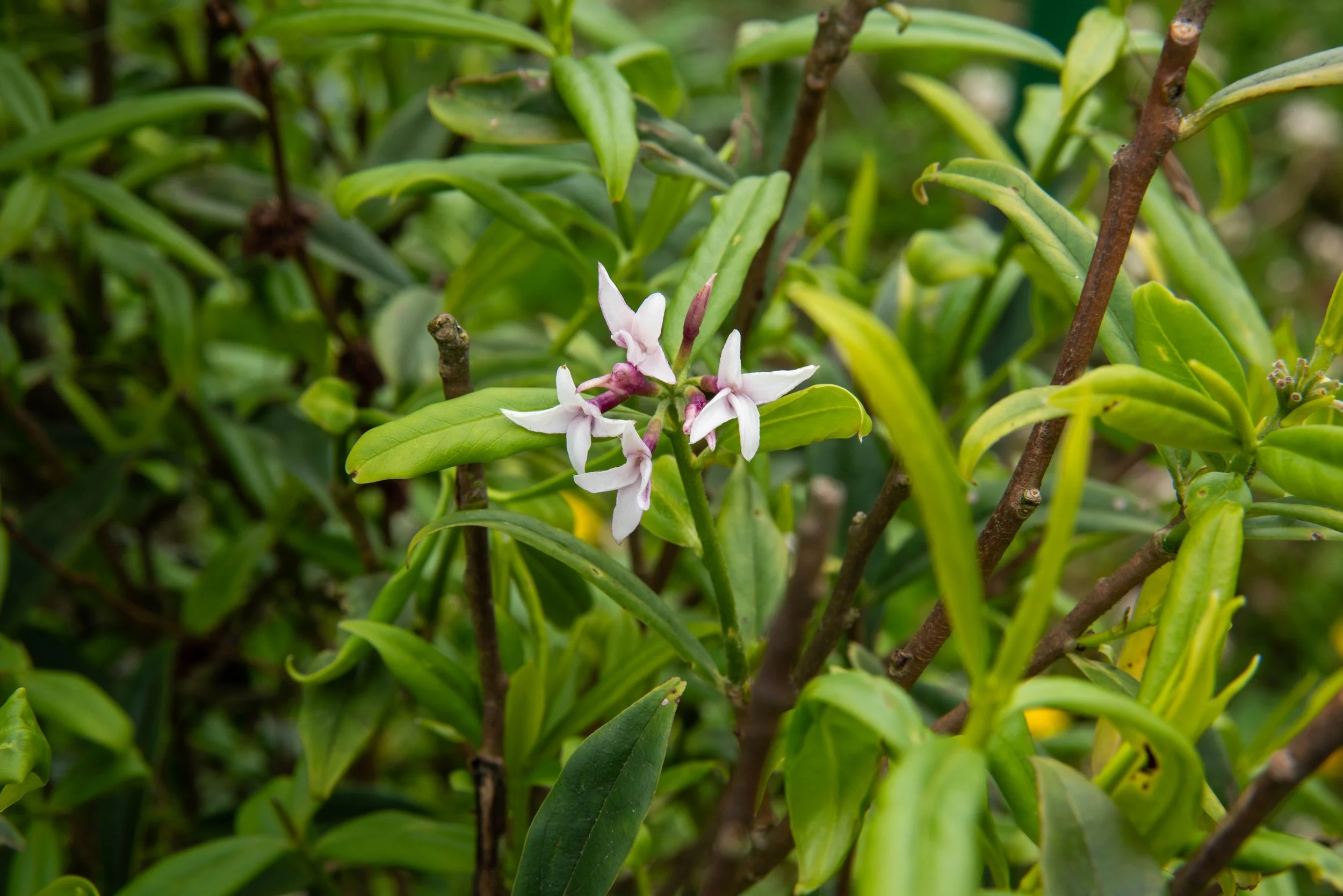
Near a panoramic photograph that labels the Himalayan peaks normally viewed from the Dochu La pass, we found several daphne bushes in flower. The flower is similar to the species Daphne odora we have in our garden but this is Daphne bholua, an alpine species commonly known as the Nepalese paper plant. The bark of this daphne bush is used to obtain the fibre for making paper as we’d seen yesterday in Thimphu.

Daphne

Having now reached the Punakha district we drove to the village of Metshina about 11 km south of Punakha.

We then set out on foot to visit the the Temple of the Divine Madman. The pathway we followed was difficult to negotiate being narrow, muddy and undulating. At one point we decided it was easier to avoid the path and walk across a rice paddy area and then a barley paddock where the gain was being hand harvested.

Our pathway across the rice paddies, Punakha

After following a quite devious pathway we reached a hillock where we encountered the yellow roofed Chimi Lhakhang built in 1499 to honour the ‘Divine Madman’, Lama Drukpa Kunley.

Chimi Lhakhang

Inside the temple is the central statue of the vagabond lama plus other statues of his supporters.

Lama Kunley was a social critic who taunted the hypocrisy of the established religious orders as well as the monastic order. Thus the use of his phallus as a ‘flaming thunderbolt’ weapon symbolises the “discomfort that society experiences when facing the truth”.

Childless women come to this temple to receive a wang (blessing) from the saint and are then to be rewarded with the increased chance of pregnancy! We observed a young woman carrying a very large wooden black penis as a backpack as she walked around the temple perimeter three times to boost her chances of conception.

Childless woman carrying phallus for fertility, Chimi Lhakhang

Pathway from Chimi Lhakhang

The souvenir shops all around Chimi Lhakhang have for sale dozens of phalluses of all shapes and sizes and even houses have penises painted on their walls. This Punakha phallus obsession is quite extraordinary and has its origin entirely from the teachings of the ‘Divine Madman’!

Souvenir shop, Chimi Lhakhang

In the post luncheon session we drove to the confluence of the Mo Chhu (Mother River) and the Pho Chhu (Father River) where commanding the river junction was the Punakha Dzong. This massive structure is generally regarded as Bhutan’s most impressive building.

Confluence of the Mo Chhu (Mother River) and the Pho Chhu (Father River)

Punakha was Bhutan’s capital for over 300 years and it was only in 1955 that the capital was moved to Thimphu. Although the Punakha Dzong previously functioned primarily as the royal palace, it now serves as the winter residence of about 200 monks. Within the massive building are three courtyards, several temples, administrative offices and monks’ accommodation. The jacaranda trees in the Dzong’s garden were in flower and looked spectacular.

Punakha Dzong

Bridge to the Punakha Dzong

An unusual sight was to see a proud rooster wandering amongst masses of visitors, completely unperturbed by the crowds. This one rooster has been anointed as the Dzong’s rooster and is to be protected until it finally dies. It revered status is indicated by the gold paint that had been added to his comb.

Rooster

Rooster

Not far from the Dzong is the 160 m long suspension bridge across the Pho Chhu river.

We walked across the swaying foot bridge with its adornment of prayer flags  draped at every possible point. An official keeps an eye on numbers of visitors allowing no more than 100 on the bridge at any one time.

Suspension bridge across the Pho Chhu river

Our day’s sight seeing finished here and we then had our friendly driver Tenzin take us to our Lobesa Boutique Hotel overlooking the rice paddies along the Pho Chhu River.

Tomorrow we continue our tour around the Punakha district.

DAY 14: Wednesday 14th May 2025 PUNAKHA; BHUTAN

After breakfast we drove about 20 km following up the Mo Chhu River valley to a spot on the river bank where several white-water rafting companies start their operations.

This was to be the starting point for our hike to the Khamsen Yuelley Namgyal Chorten. It was raining sufficiently to dampen not only our clothing but also our enthusiasm for the climb ahead.

With raincoats now on we headed off by firstly crossing the suspension bridge over the Mo Chhu river. The next four hundred metres of muddy track meandered amongst terraced fields growing chilies, maize, rice and cabbages. Having reached a sheltered area enclosing a large prayer wheel we then commenced a steady climb to the top. The track was narrow, slippery and quite uneven in most places until we were near the chorten where we went through a gateway and from there on the pathway was paved with interlocking flat stones.

Suspension bridge over the Mo Chhu River,

Hike to the Khamsen Yuelley Namgyal Chorten

It took us about forty minutes to reach the temple, a total distance of 1.6 km and in so doing we’d gained 194 m in altitude.

The Khamsen Yuelley Namgyal Chorten is 30 m tall and took eight years to build. It was consecrated in 1999 and dedicated to the fifth king.

Khamsen Yuelley Namgyal Chorten

Jakarandas, Khamsen Yuelley Namgyal Chorten

Protector Avalokiteshvara

Its purpose is to protect Bhutan so it is veritably packed with every conceivable member of Bhutanese demonography including a four metre high bronze statue of the protector Avalokiteshvara the deity embodying Buddha’s compassion. Many of the demons are covered with flames and have contorted faces as if in abject pain.

The rain had stopped and we climbed to the third floor rooftop of the chorten and although the atmosphere was a little misty we had an expansive view below us of the Mo Chhu valley and its rich agricultural fields.

View from the top of Khamsen Yuelley Namgyal Chorten

View from the top of Khamsen Yuelley Namgyal Chorten

The walk back down to the river was treacherous due to the slippery clay surface following the rain we’d just had this morning.

Path to Khamsen Yuelley Namgyal Chorten

Descending from Khamsen Yuelley Namgyal Chorten

During the descent we spotted, along the side of the track a number of flowering turmeric plants. The flower has delicate waxy white petals with purple tips. It is a member of the ginger family and the powder is obtained from the tumeric’s underground rhizomes or tubers.

Tumeric plant

About 6 km south of Punakha we peeled off the main road and commenced a long climb (in the bus) to the Sangchen Dorji Lhendrub Choling Nunnery. This is a Buddhist college for 120 resident anim (nuns) which was financed by the fourth king’s father in law!

Sangchen Dorji Lhendrub Choling Nunnery

The central feature is a large stupa or chorten and adjacent is a temple with various Buddhist statues of gods most being covered in gold.

Stupa, Sangchen Dorji Lhendrub Choling Nunnery

The nuns have shaved heads and wear maroon habits making their appearance so similar the the male monks.

The nunnery has a large surrounding garden in which there are twelve or so small stupas representing the different architectural styles and corresponding religious significance.

After a late lunch we made a brief visit to a site, 17 km south of Punakha where we could observe the Wangdue Phodang’s Dzong (fortress) atop a strategic ridge. It was founded in 1644 and gave the penlop (leader) of Wangdue Phodrang at that time a very strong strategic  military position.

Bridg to, Wangdue Phodang’s Dzong

Wangdue Phodang’s Dzong

The dzong burnt to the ground in June 2012 as it had done in 1837 and the present day rebuilding only finished in 2022.

Bridge to Wangdue Phodang’s Dzong

We then returned to our Lobesa Boutique Hotel at around 16:30 for opportunities to catch up on diaries, washing and some well earned rest after a day involving a good deal of climbing and exertion.

DAY 15: Thursday 15th May 2025 PUNAKHA - PARO; BHUTAN

We departed Punakha at 09:30 and joined the scenic highway for our 120 km trip to Paro. As had been the case earlier in the week the mountain pass became very foggy as we approached the high point at Dochu La.

Forest in mist, approaching high point at Dochu La, Bhutan

A few kilometres before reaching Dochu La we stopped at a small chorten just off the side of the road. The area was adorned with prayer flags extending in every direction and there were literally hundreds of small, gold painted Buddhist temples perched on the road-side rocks. These are ‘offerings’ to hopefully bring health and well-being.

Our bus parked on side of road, approaching high point at Dochu La

Miniature painted Buddhist temples

The chorten had a one metre high prayer wheel inside being turned by the flow of water past paddles beneath. The prayer wheel struck a bell on each revolution and made a sound that reverberated amongst the misty surrounding forest.

Chorten with prayer wheel

Prayer wheel inside chorten

Along the side of the road we noticed large numbers of wild miniature strawberry plants in flower and quite a few had little strawberries ready for eating.

Wild strawberries

We crossed over the Dochu La pass but did not stop as the low cloud meant that any Himalayan mountain range view was out of the question.

On descending the highway towards Thimphu we diverted to visit the Simtokha Dzong. This historic Dzong was built by Zhabdrung Namgyel in 1629 making it the oldest fortress in Bhutan.

Simtokha Dzong

The Dzong is now used as a monastery and houses the Bhutan School for Buddhist Studies.

We cautiously entered the main central prayer hall to find about fifty monks squatting on long parallel mats chanting Buddhist text and ringing bells every few seconds. At one stage the chanting stopped briefly and leather drums were beaten as long brass trumpets let out mournful sounds reminiscent of bagpipes.

We then bypassed Thimphu and headed for Paro with the only stop being to view an ancient house built over 400 years ago. We suspect that the red corrugated iron roof was not from the 17th century! Also at this stopping point was a roadside shop selling vegetables, fruit and white yak’s cheese. The cubes of yak’s cheese were threaded onto strings which dangled from the shop’s awning.

Traditional Bhutanese house

Roadside vegetable store selling yak's cheese

Having now arrived in Paro we had a late lunch and then visited the Ta Dzong which was formerly a watchtower but since renovation in 1968 it now serves as the National Museum of Bhutan.

We first entered an adjacent annexe displaying modern day Buddhist art work by Penjor Dorji all done using natural dyes and colouring agents. In an adjacent room were hundreds of Dharma masks worn during sacred religious dances.

 There were other artefacts in display too including a 10th century copper head of Buddha which is believed to have been damaged by fire.

Dharma masks

Copper head of Buddha

The unusual main museum is a circular four storey building said to be in the shape of a conch shell with 2.5 m thick walls and an underground tunnel thought to lead to water below.

National Museum of Bhutan building

Common raven, Bhutan's National bird in the grounds at National Museum of Bhutan

The extensive collection includes antique Thangkha paintings, textiles, weapons and armour, household objects and a rich assortment of natural and historical artefacts.

A number of stone adzes from around 2000 BC were on display. Some were actual meteorites and the story goes that the early Bhutanese farmers thought these stones from the heavens were ‘namche tare’ or powerful axes hurled down as weapons to assist in battles.

There was also a tooth relic of Zhabdrung’s pet dog. Zhabdrund was a great 17th century Buddhist leader and statesman.

A further exhibit of peculiarity was a mare’s egg! A mare allegedly gave birth to this egg in her stable in the 1920s. It attracted a lot of attention and was later donated to the museum in 1968 by the late queen mother.

One final display that caught our interest was the water clock which measures astrological time which is apparently 2.5 times slower actual time!

Mare’s egg

Chusangkhorlo (Water Timer)

From the terrace outside the museum we could see the rich paddy fields below and the airport where we’d landed last Sunday. We watched a plane make its precarious final turn after leaving the valley and come in and land.

View over Paro from National Museum of Bhutan

We then moved to our accommodation at the Hotel Kaachi Grand.

Tomorrow we have five hour mountain trek to visit the Taktshang Monastery offer referred to as the Tiger’s Nest.

DAY 16: Friday 16th May 2025 PARO; BHUTAN

It was to be an early start today as we had in front of us a five hour trek to the Taktshang Monastery frequently referred to as ‘Tiger’s Nest’. It is probably the most famous of all the Buddhist monasteries in Bhutan as it sits perched on the side of a massive cliff 900 m above the Paro River and township below.

It gained its name as supposedly Guru Rinpoche arrived at this high location on the back of a tigress and meditated at the tiny monastery that was built here in the 1600s.

The site has been recognised as a most sacred place since 1646 and is supposed to be visited by all Bhutanese at least once in their lifetime.

In April 1998 a fire severely damaged the main structure but now this Bhutanese jewel has been restored to its original splendour.

Our driver Tenzin dropped us off at the base of the mountain and although some people elected to use horses for transport we decided to do the hard slog and set off on foot.

We started in blue pine forest and passed several water powered prayer wheels and then as the track got steeper we entered areas with lots of deep red coloured flowering rhododendrons. There were masses of people making this ‘pilgrimage’ and many of them were Indians. The term ‘Indian file’ for our progress up the mountain was entirely appropriate.

Prayer wheels beside the track

Rhododendron

After just over one hour of climbing we reached a point where the Tiger’s Nest was visible in drifting mist but there was still a long way to climb.

After two hours we’d passed the Taktsang Café and thirty minutes later we reached a high point at around 3140 m where there was a stupa and we should now have been able to see the monastery if it had not been for the cloud.

As there was no alternative, we decided to continue on down into the deep valley between the lookout and the monastery which is only 150 m horizontally across the gorge.

Our first view of the Tiger's nest across the gully

The trail descends about 360 steps to a waterfall next to the ‘Snow Lion Cave’ and then we had the final ascent of 250 steps to reach the monastery. The climbing at above 3000 m becomes a little more difficult due to the (~10%) lower oxygen availability.   

Waterfall next to the ‘Snow Lion Cave’,

At the monastery we rested and took photos in a fairly misty atmosphere but were not permitted to enter inside as we didn’t have passes.

The Monastery

The return journey was better as the cloud was lifting and the sun was breaking through so we managed to get some clearer photos.

The Monastry from the view point, Tiger's Nest walk

Corinne & Jak with the Monastry across the gully

The downhill pathway return was pleasant as we were on our own for much of the time. We arrived back at the bus after 4 hours 20 minutes hiking, a distance of 8.87 km with the ascent achieving a gain in altitude of 686 m.

Jak on the track

Corinne on the track

Monastery from the cafeteria

After another late lunch break we drove to the Drugyel Dzong fortress which was built in 1600 and then was gutted by fire in 1648. It is now in the process of being rebuilt.

Drugyel Dzong

In the 17th century this fortress played a major role in deterring the invading Tibetan warriors who crossed the mountain pass just behind Drugyel Dzong.

We could see the snowy dome of Chomolhari (“goddess mountain”).

Snow on Chomolhari (“goddess mountain”)

As our final activity for Bhutan, we visited an archery group and watched with amazement as archers fired arrows over a 140 m path to a fairly small target. Several hit the target and most were quite close. The bows were home made from two pieces of springy timber bound together with string and tape.

Lamgong archery ground

This has been our final day in Bhutan and it entailed the challenging hike which we coped with pretty well. On the day we were probably the oldest couple who did the whole trek which resulted in a number of complimentary comments from other younger hikers.

Tomorrow we leave Bhutan and move on to India where we can expect much hotter temperatures.

We’ve loved our time in Bhutan and feel very fortunate to now have some better understanding and appreciation for this remarkable jewel of Asia.

DAY 17: Saturday 17th May 2025 PARO; BHUTAN – NEW DELHI; INDIA

We arrived at the Paro Airport at 09:30 and said farewell to our Bhutanese guide Dendup and our highly capable driver Tenzin.

We had business class seats which meant that we went through the baggage drop and ticket allocation quite quickly and efficiently.

At this point we had to say farewell to Sue who is not travelling on to India with us and is heading home to NSW via Singapore. There were lots of hugs and good wishes as our team of six suddenly became five.

Three of our five were suffering from yesterday’s luncheon with stomach upsets which resulted in everyone being fairly low key and wanting rest and not feeling like eating.

We had access to the Drukair Business lounge but just used it as an opportunity to relax in a comfortable surrounding.

We boarded our Airbus 319 and took off in the direction of the infamous valley and gorge but as we were climbing rapidly the danger associated with the descent into Paro is not so significant.

Boarding the plane for Delhi

The flight took 150 minutes and there were times that passengers on the right side of the plane could see some of the Himalayan peaks but most were cloud covered.

Coming in to land at New Delhi gave us a clear snapshot as to why this is the most populous country in the world. Even 20 km before landing the residential blocks were jammed so close together that there wasn’t the possibility of trees or gardens.

Flying into Delhi

Flying into Delhi

We landed at Indira Gaandhi International Airport and were able to access the business class passport and immigration ‘fast lane’ and were through in no time.

Our group of five all caught up at the luggage carousel and then used an ATM to collect some Indian rupees. The current exchange rate is around 55 Indian rupees to the Aussie dollar.

Having passed through customs without there being any declaration required we proceeded to the arrivals gate where we were met by a ‘Go India Experiences’ company representative who led us to our bus and we then headed in to New Delhi Dwarka. The outside temperature was 42C and the air-conditioning in our bus is a godsend.

The travel from the airport to our hotel was in heavy traffic with cars, buses, small trucks, motor bikes and cyclists all honking horns and weaving about and creating more lanes than theoretically existed.

At some intersections we were held up for extended periods and on one occasion, next to us was an elderly man riding a bicycle. Despite this mayhem he had strapped to his bike frame a 3 m long section of large diameter PVC pipe. He seemed to survive the jostling and near misses that occurred frequently.

We are staying in the Raddison Blu Hotel in the suburb of Dwarka.

On arrival at 15:00 Delhi time we all decided that we’d head for our rooms and go into hibernation until tomorrow morning when we do a tour of Old Delhi.

DAY 18: Sunday 18th May 2025 DELHI; INDIA

The city of Delhi with a population of just over 20 million can be conveniently divided into four distinct regions.

The most northern, oldest and smallest part is Old Delhi, situated on the banks of the Yamuna River.

Just south Old Delhi is the four times larger region of New Delhi which is more modern and was largely developed during the time of British rule. Between New Delhi and the Yamuna River to the east is the third region of Nizamuddin to Feroz. However, by far the largest region is South Delhi which has come about as numerous smaller cities have expanded over the last hundred years or so to overlap creating the present day metropolis.

Our plan for the day was to spend most of the time in Old Delhi. We were met by our Delhi guide and then driven in our comfortable eight-seater bus northwards for about an hour.

A significant portion of our travel time was through the military sector where for several kilometres we passed walled army grounds enhanced by large numbers of trees, especially the laburnums with their pendulous yellow flowers. We passed the India Gate, a striking arched memorial to soldiers who died in World War 1.

Laburnum trees

As we entered Old Delhi the scene changed dramatically when we encountered the market area. The population density on either side of the road was beyond imagination with shoulder to shoulder traders selling shoes, clothing, cheap jewellery and various household items. Often the wares were encroaching on the roadway and in one spot, in amongst a bundle of cheap clothing was a man asleep oblivious to the traffic passing close by.

Rickshaws in market area

Market area

Our first stop was at the Jama Masjid Mosque. This mosque was built on the orders of the Emperor Shah Jahan the architecturally eager Mughal ruler whose other famous commission was the Taj Mahal.

The grand Jama Masjid Mosque took six years and a force of 5000 workers to construct.

The mosque is an imposing sight with three large black and white marble domes and twin towering minarets framing its great central arch. The mosque was completed in 1656 and is India’s largest.

Jama Masjid mosque

Jama Masjid mosque with bathing pool in front

The internal sanctions of the mosque that we were allowed to see were made from predominantly red sandstone with many walls having intricate patterns of inlaid marble.

InsideJama Masjid mosque

There are three elaborate gates on three sides of the central courtyard with the one opposite the mosque, the ‘Royal Gate’ only to be used by the Emperor or government officials nowadays. On holy Fridays the courtyard can have up to 25,000 Muslims gathering for prayers.

Royal Gate, Jama Masjid mosque

We left the mosque and climbed into rickshaws and were peddled through the back street market area and eventually to Chandni Chowk one of the main streets through this section of Old Delhi. It’s a bustling market area regarded as the heart of the old town. This busy thoroughfare is lined with colourful markets and shrines.

Corinne & Jak on rickshaw

Chandri Chowk (moonlight street) on Sunday (most shops closed)

Chandri Chowk (moonlight street) on Sunday

As we went by in our rickshaw we photographed the distinctive towers of the Lal Mandir one of the most revered Jain temples in India.

Towers of Lal Mandir

Our ride terminated at The Red Fort.

Red sandstone embattlements give this imperial citadel its name Lal Quila or Red Fort.

Embattlement Wall of Lal Quila (Red Fort)

Commissioned by Shah Jahan in 1639 it took nine years to build and was the seat of Mughal power until 1857 when the last emperor was dethroned and exiled.

The high sandstone Fort wall encloses an area of about 250 hectares and in former times was surrounded by a moat. The internal area is open lawns and trees with several palatial buildings and pavilions. We were very impressed with the intricately carved sandstone arches and pillars of the Diwan-i-Aam and the Emperor’s massive canopied throne carved from marble.

Diwan-i-Am (Hall of public audience), Lal Quila (Red Fort)

Inside Diwan-i-Am (Hall of public audience), Lal Quila (Red Fort)

Emperor's throne, Diwan-i-Am (Hall of public audience)

Amongst the trees we encountered three or four Indian squirrels which hopped merrily across in front of us without concern.

Indian squirrel

Our final site to visit for the day was Raj Ghat the site of Mahatma Gandhi’s cremation. It is regarded as the most revered symbol of Indian Nationalism.

Within a tranquil garden is a sombre black granite platform inscribed with Gandhi’s last words, Hey Ram (‘Oh God’).

Raj Ghat (the site of Mahatma Gandhi’s cremation)

This simple monument was covered with garlands of orange marigolds and behind the granite platform a flame burns eternally for the ‘Father of the Nation’. The garden setting takes on special prayer gatherings and ceremonies on the 2nd October commemorating Mahatma Gandhi’s birthday.

By this time of the day the temperature was climbing into the mid-thirties and we elected to head back to our hotel for cool showers and refreshments.

Our van outside the Radisson Hotel, New Delhi

It’s been a most interesting six hours in Old Delhi today and given us an opportunity of learning a little more about India’s history as well as seeing many, many Indians going about their everyday lives.

Tomorrow we spend much of our time visiting places in New Delhi.